What is GPS? Global Positioning System & How It Works
We interact with satellite navigation every day, whether we are checking a map app on our phone or tracking a food delivery. But for commercial transport operators, this technology is the absolute foundation of the business. Running a logistics operation without highly accurate location data is like driving in a heavy fog. Without it, planning routes,securing high-value assets, and managing daily costs becomes pure guesswork.
The Global Positioning System (GPS) is essentially a network of satellites that broadcast radio signals, allowing a receiver on Earth to compute its precise location, velocity, and time. To understand how it really works for organizations,it’s important to clear up a frequent misperception regarding the GPS meaning. We often use the term “GPS” to refer to any type of tracking system, but it actually refers to a specialized satellite navigation network established and operated by the United States military. It is only one component of a much greater global puzzle: the Global Navigation Satellite System. For international fleets crossing complex borders and congested transit corridors, relying solely on a single country’s satellite network is no longer sufficient to ensure continuous, uninterrupted visibility on the road.
The Three Segments of GPS
To maintain millimeter-level atomic precision across global logistics networks, the architecture of satellite navigation is divided into three distinct, interdependent layers:
- The space segment. A group of at least 24 operational satellites orbiting Earth in six MEO (Medium Earth Orbit) planes at an altitude of approximately 20,200 kilometers. Each satellite orbits the planet twice a day, continuously broadcasting one-way radio signals containing its precise orbital parameters (ephemeris data) and a highly synchronized time stamp.
- The control segment. A global network of ground-based master control stations, monitor stations, and dedicated ground antennas. This infrastructure is responsible for tracking the operational health of the satellites, measuring minute orbital drifts, correcting clock anomalies, and uploading fresh navigational messages back into orbit.
- The user segment. The actual hardware receiver is embedded within commercial telematics infrastructure, such as Ruptela on-board tracking units.
The user segment is the only touchpoint the fleet operator directly deploys. This hardware captures the faint radio frequencies traversing the atmosphere and decodes them into highly structured data packages used for business intelligence.
How GPS Works: The Science of Trilateration
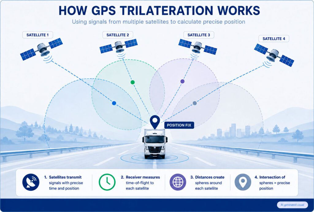
The core navigation mechanism that allows a vehicle to locate itself on a map using modern GPS technology is known as trilateration. While triangulation (which finds locations by measuring angles) is sometimes mistaken with trilateration, the latter only calculates the precise distance between a receiver and many known points in space.
Consider a simple physical example to help you comprehend this without using complex mathematical computations. If you’re lost in an expansive terrain and a guide tells you you’re exactly 50 kilometers from Landmark A, you may be anywhere inside a complete 2D circle of that landmark. If a second guide tells you you are 30 kilometers from Landmark B, your prospective position is limited to the two specific spots where the two circles meet. By adding a third distance from Landmark C, the circles overlap at a single unique location.
In actual fleet tracking scenarios, this geometric calculation occurs in three dimensions using spherical intersections based on the time-of-arrival concept:
- Signal transmission. The satellite broadcasts a radio signal containing its exact position and the precise nanosecond at which the transmission began.
- Time-of-flight measurement. The vehicle tracker’s internal clock records the exact moment the signal is received. Radio waves travel at the speed of light, thus the time delay tells the hardware the exact distance to that specific satellite.
- Sphere intersection. The receiver projects a theoretical sphere around each satellite based on the calculated distance. The intersection of these spheres defines the tracker’s physical position.
Because the system operates in three-dimensional space (latitude, longitude, and altitude) and standard vehicle trackers lack multi-million-dollar atomic clocks, a minimum of four satellites is required to achieve a stable position fix. The first three satellites establish the spatial coordinates, while the fourth satellite resolves the clock bias between the tracker’s internal crystal oscillator and the satellite constellation’s atomic time.
GPS vs. GNSS: Why It Matters for Global Fleets
GPS is a subset of GNSS, however receivers are classified as GPS (GPS-only) or GNSS. For large commercial fleets traveling across continents, depending solely on a single country’s satellite array exposes the supply chain to positional drift, signal attenuation, and localized blind spots. The Global Navigation Satellite System (GNSS) refers to all active global satellite constellations.
| Constellation Name | Operating Authority / Region | Operational Frequencies | System Type |
|---|---|---|---|
| GPS | United States Space Force | L1, L2, L5 | Global |
| Galileo | European Union / ESA | E1, E5a, E5b, E6 | Global |
| GLONASS | Russian Federation | L1, L2, L3 | Global |
| BeiDou (BDS) | China National Space Administration | B1C, B1I, B2a, B2b, B3I | Global |
Industrial-grade telematics hardware uses multi-GNSS modules that track multiple constellations simultaneously. For a fleet manager, the primary technical advantage of this multi-constellation approach is a drastic reduction in Time-to-First-Fix (TTFF) and a significantly higher level of positional stability.
This multi-frequency setup is essential for driving through urban canyons, typified by tall glass buildings that block low-horizon satellite views. When a normal GPS-only device loses line-of-sight to the American constellation, a multi-GNSS receiver smoothly supplements the location computation with overhead European Galileo or Chinese BeiDou satellites, preventing data dropouts.
What Affects GPS Accuracy?
Even with accurate atomic clocks, satellite radio transmissions must travel thousands of kilometers across hazardous space before reaching a vehicle’s antenna. This vulnerability means that raw navigational data is susceptible to environmental degradation, causing locations to appear to hop or drift on a map.
- Atmospheric delays. Radio waves are refracted as they travel through the Earth’s ionosphere and troposphere. This refraction slightly reduces the wave velocity, leading to minor errors in the time-of-flight equation.
- Multipath propagation. A satellite signal could be delayed before it reaches your car’s antenna in crowded industrial areas, mountain passes, or densely populated cities. The vehicle’s position on the dashboard is momentarily distorted because the receiver perceives the delayed reflected signal as a longer distance.
- Signal jamming and spoofing. Illegal localized RF transmitters can flood civilian GPS frequencies with white noise (jamming) or broadcast false positioning data (spoofing) to mask unauthorized vehicle detours or facilitate asset theft.
Enterprise telematics solutions avoid using raw, unconfirmed satellite data to maintain professional data integrity. Physical RF filtering and anti-jamming detection are features of high-performance tracking hardware. The software behind modern fleet management solutions uses methods such as dead reckoning and Kalman filtering to compare satellite data with vehicle acceleration patterns. This helps to eliminate irregular multipath jumps and provide a navigation route record that can be legally defended via professional GPS technology.
From Satellites to the Dashboard: The Telematics Journey
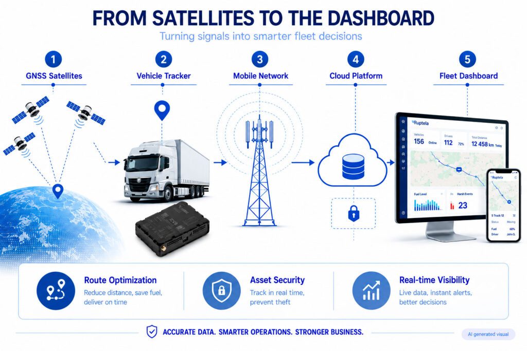
A raw latitude and longitude coordinate stored in a hardware receiver has no value to an active logistics operation. Changing that space-born navigation radio wave into a highly accurate, actionable fuel or operational report requires an end-to-end telematics pipeline.
The first step is for the tracking device to receive signals from many GNSS systems and determine its precise location. At the same time, the device uses non-intrusive connection protocols, such as EasyCAN, to connect directly to the vehicle’s internal nervous system via the CAN bus or the FMS interface. With this connection, the gadget may retrieve odometer readings, engine RPM, accurate throttle settings, and hardware-validated telemetry such as fuel injector data.
The tracker then uses secure protocols such as MQTT or TCP/IP to package and send telemetry across local cellular networks, whether GSM, LTE, or 5G. The data includes both position and engine diagnostics. An algorithm processes the raw telemetry stream once it is transmitted to a centralized cloud server. Fleet managers view compliance reports, graphical graphs, and immediate idle alarms on their software dashboards thanks to the cloud infrastructure’s millisecond-long transformation of the binary packets.
Practical Uses of GPS in Fleet and Asset Management
In addition to serving as a digital road map, modern GPS technology operates as an optimization engine at the heart of business operations, influencing profit margins in a wide variety of niche industries:
- Logistics & long-haul transport. Transcontinental freight lines use continuous location data to calculate exact route compliance, minimizing wasteful out-of-route mileage and containing variable operational wear. To secure clean data flows over multi-year asset lifecycles, following structured GPS tracker installation tips prevents signal loss and wiring degradation.
- Cold chain management. By linking high-precision location logs with wireless Bluetooth Low Energy (BLE) temperature and humidity sensors, dispatchers receive real-time visibility into refrigerated cargo environments, generating automated compliance logs required for food and pharmaceutical transport.
- Construction & heavy machinery. High-value yellow goods operate in remote, off-road environments. Telematics units track precise engine hours under load rather than simple mileage, while virtual geofences protect assets from unauthorized weekend use or theft.
- Agriculture (agri-tech). Modern farming operations rely on spatial mapping to coordinate the movement of combine harvesters and tractors, optimizing field coverage patterns, reducing overlapping passes, and tracking fuel burn rates during intensive harvest windows.
- Last-mile delivery. High-density urban distribution networks leverage real-time positioning to dynamically re-route couriers based on localized traffic patterns, shortening delivery windows and supplying customers with high-accuracy Estimated Times of Arrival (ETAs).
- Car sharing & rental. Shared mobility networks automate their entire billing and deployment lifecycle by tracking exact vehicle distribution, monitoring mechanical diagnostic status, and establishing automated drop-off zones via precise geofencing parameters.
The Business Benefits of High-Precision GPS
Investing in a business-grade fleet tracking system is a smart move that will pay for itself in the long run by cutting down on administrative burden, risk, and waste:
- Strategic route optimization. Eliminating unnecessary mileage directly reduces fuel consumption, which typically constitutes up to 30% of a commercial fleet’s total operating expenses.
- Geofencing & asset security. Automating monitoring procedures and sending quick security warnings if an asset travels outside specified bounds is made possible by creating high-definition digital perimeters around logistical hubs or client delivery zones.
- Accelerated theft recovery. Increased recovery success rates and protection of capital assets from total-loss write-offs are enabled by real-time location streaming, which provides law enforcement with exact asset coordinates during an active theft incident.
- Indisputable proof of delivery (PoD). A digital ledger of drivers’ arrival times is generated from automated geofence entrance and departure timestamps, helping resolve billing disputes promptly and strengthening relationships with B2B clients.
Examining the detailed operational mechanics described in the benefits of GPS vehicle tracking sheds light on how high-precision spatial telemetry safeguards business margins, which is necessary for comprehending how these many data streams fit into an all-encompassing plan to reduce costs.
Conclusion: Choosing the Right GPS Hardware
The data your company collects depends entirely on the technology you choose for your vehicles, even though the navigation signals broadcast by orbiting satellites are a universal standard. Low-priced or consumer-grade tracking devices often have chronic signal drift, can’t handle sophisticated CAN bus decoding, and break down quickly from the heat and vibrations of professional use.
To secure reliable, high-fidelity tracking data under any operational conditions, explore the full capabilities of the professional Ruptela tracker portfolio or evaluate the heavy-duty diagnostic power of the HCV5 advanced tracking series to select the engineered hardware solution tailored to your operational scale.